History
Biography
Geography
Science
Games
Search Ducksters
Geography
>>
US States
Virgin Islands
Capital:
Charlotte Amalie
Population:
104,914 (2018 estimate) (Source: 2012 U.S. Census)
Major Cities:
Charlotte Amalie
Borders:
Gross Domestic Product (GDP):
Key Industries:
How Virgin Islands got its name:
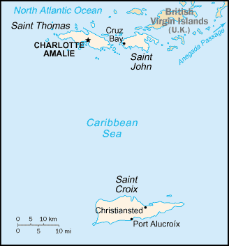
Click on map for larger view
Virgin Islands State Symbols
State Nickname:
The American Paradise
State Slogan:
none
State Motto:
United in Pride and Hope
State flower:
Yellow Elder
State bird:
Yellow Breast
State fish:
State tree:
none
State mammal:
State foods:
Becoming a State
Date admitted:
NA
Number admitted:
NA
Prior Name:
NA
Postal Abbreviation:
VI
The Geography of Virgin Islands
Total Size:
1,910 sq. miles
Geographical Low Point:
Atlantic Ocean at Sea Level (source: U.S. Geological Survey)
Geographical High Point:
Crown Mtn. at 1,556 feet, located in the county/subdivision of St. Thomas Island (source: U.S. Geological Survey)
Central Point:
Counties:
2 Districts
Bodies of Water:
Famous People
Fun Facts
The US Virgin Islands is not a state, but is an 'insular area' of the United States. An insular area is like a territory that is an island.
In Denmark, the US Virgin Islands are referred to as The Former Danish West Indian Islands.
The National Anthem is the Virgin Islands March.
Nicknames for the islands are 'Rock City' for St. Thomas, 'Love City' for St. John, and 'Twin City' for St. Croix.
Road traffic on the Virgin Islands is on the left hand side of the road.
Columbus visited the islands in 1493. Over the next 50 years the entire native population had died out.
Sugar cane was an important crop for many years.
The USA purchased the islands from Denmark for $25 million.
The official language is English.
Tourism is the main industry on the islands. Over 2 million people visit them each year.
Professional Sports Teams
Geography
>>
US States
For state symbols, flag, maps, geography, and fun facts:
Alabama
Alaska
Arizona
Arkansas
California
Colorado
Connecticut
Delaware
District of Columbia
Florida
Georgia
Hawaii
Idaho
Illinois
Indiana
Iowa
Kansas
Kentucky
Louisiana
Maine
Maryland
Massachusetts
Michigan
Minnesota
Mississippi
Missouri
Montana
Nebraska
Nevada
New Hampshire
New Jersey
New Mexico
New York
North Carolina
North Dakota
Ohio
Oklahoma
Oregon
Pennsylvania
Puerto Rico
Rhode Island
South Carolina
South Dakota
Tennessee
Texas
Utah
Vermont
Virgin Islands
Virginia
Washington
West Virginia
Wisconsin
Wyoming