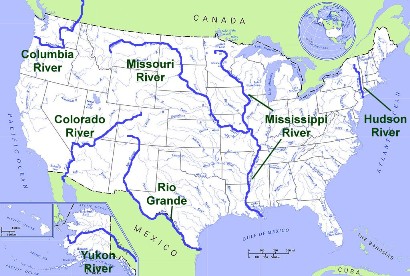
The Mississippi River is one of the most important rivers in the United States. It flows 2,340 miles north to south from Minnesota to the Gulf of Mexico in Louisiana. Together with the Missouri River, it forms the fourth largest river system in the world. The source of the Mississippi is Lake Itasca in Minnesota.
In the early history of the United States, the Mississippi River served as the westernmost border of the country until the Louisiana Territory was purchased from France in 1803. After that, the river was a symbol of the start of the American frontier. Today the river is an important transportation waterway, carrying goods from the middle of the country to the port of New Orleans and into the Gulf of Mexico.
The Mississippi River travels through several states including Louisiana, Mississippi, Tennessee, Arkansas, Kentucky, Missouri, Illinois, Iowa, Wisconsin, and Minnesota. It acts as the border between several of these states. It also travels through several major cities including Minneapolis, St. Louis, Memphis, and New Orleans.
Missouri
The Missouri River is the longest river in the United States at 2,540 miles long. Together with the Mississippi River, it forms the fourth largest river system in the world. It begins in Western Montana and flows to the Mississippi River just north of St. Louis. It travels through several states including Montana, North Dakota, South Dakota, Iowa, Nebraska, Kansas, and Missouri.
The first explorers to travel the entire length of the Missouri River were Lewis and Clark. They used the Missouri to make their way west when exploring the Louisiana Purchase. The river played an important role in the early history of the American frontier as the major trails to the west, such as the Oregon and Santa Fe Trail, began at the Missouri River.
Rio Grande
The Rio Grande flows 1,900 miles from Colorado to the Gulf of Mexico. Along the way it travels through New Mexico and serves as the southern border of Texas between the United States and Mexico. Major tributaries of the Rio Grande include the Rio Conchos, the Rio Chama, and the San Juan River.
Hudson
The Hudson River flows 315 miles north to south in eastern New York. It is a fairly short river when compared to many of the other rivers on this page. However, the Hudson played an important role in the early history of the United States. When the Erie Canal was opened in 1825, the Hudson was connected to the Great Lakes. This created a trade route from the Atlantic Ocean to the Great Lakes region. It had a major impact in the growth of New York City.
Colorado
The Colorado River flows 1,450 miles from the Rocky Mountains of Colorado to the Gulf of California. Along the way it passes through Utah, Arizona, Nevada, California, and Mexico. The river is famous for carving out the Grand Canyon over the course of millions of years. Today the Colorado is an important source of water and power for the southwest United States. The Hoover Dam was built on the Colorado in 1936. It formed Lake Mead and provides power to the city of Las Vegas.
Columbia
The largest river in the northwest region of the United States is the Columbia River. It stretches 1,240 miles from the Canadian Rockies, through Washington state, and along the Oregon-Washington border to the Pacific Ocean. The river is an excellent source of power and is home to Grand Coulee Dam, the largest power producing dam in the United States.
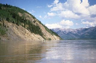
Yukon River in Alaska
Yukon
The Yukon River is the third longest river in the United States at 1,980 miles. It begins at Llewellyn Glacier in Canada and flows north to Alaska where it proceeds to travel west across the state to the Bering Sea.
Top 10 US Rivers by Length
Missouri: 2,540 miles
Mississippi: 2,340 miles
Yukon: 1,980 miles
Rio Grande: 1,900 miles
St. Lawrence: 1,900 miles
Arkansas: 1,460 miles
Colorado: 1,450 miles
Atchafalaya: 1,420 miles
Ohio: 1,310 miles
Red: 1,290 miles
* The source for the length of the rivers in this article is the USGS.