On May 18, 1980 a volcano in Washington state named Mount St. Helens erupted. It was the largest volcanic eruption in the continental United States since 1915. A giant plume of ash rose from the eruption darkening much of eastern Washington and spreading across much of the United States and Canada.
Where is Mount St. Helens?
Mount St. Helens is located in southwest Washington state, around 90 miles south of Seattle. It is part of the Cascade Mountain Range. The Cascade Mountain Range is part of a bigger geological feature called the Ring of Fire. The Ring of Fire surrounds the Pacific Ocean and is made up of hundreds of volcanoes.
Did they know it was going to erupt?
Geologists had a pretty good idea that the volcano was going to erupt. They didn't know exactly when, however. The first sign was an increase in earthquake activity in March of 1980. Throughout March and April, the mountain became more active including several steam eruptions. In April, a large bulge appeared on the north side of the volcano. At this point geologists knew the eruption would likely occur soon.
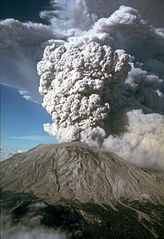
The Volcano Erupts by Mike Doukas for the USGS
The North Face Collapses
On May 18, a large magnitude 5.1 earthquake shook the area. This caused the north side of the mountain to collapse. The majority of the north side of the mountain turned into a giant landslide. It was the largest landslide in recorded history. The giant mass of earth slid at a speed of over 100 miles per hour wiping out everything in its path. The landslide hit Spirit Lake next to the mountain causing 600 foot waves.
The Eruption
A few seconds after the landslide, the north side of the mountain exploded in a giant eruption. A lateral blast shot superheated gasses and debris out of the side of the mountain at over 300 hundred miles per hour. The blast burned and blew away everything in its path. Around 230 square miles of forest were destroyed.
A giant plume of volcanic ash also formed in the air above the mountain. The plume took the shape of a mushroom cloud that rose to around 15 miles (80,000 feet) into the air. The volcano continued to spew ash for the next nine hours. Much of eastern Washington was plunged into darkness as the ash spread.
How much damage did it do?
The Mount St. Helens eruption of May 18, 1980 was the most economically destructive volcanic eruption in the history of the United States causing over $1 billion of damage. Around 200 houses were destroyed and 57 people were killed by the blast. Roads, bridges, and railways for several miles around the mountain were also destroyed. Ash covered much of eastern Washington. Airports had to shut down and people had to dig out of large piles of ash. It's estimated that around 900,000 tons of ash had to be removed from roads and airports.
Has it erupted since?
The volcano erupted several more times throughout 1980 and then calmed down. There were small eruptions until 1986 when the mountain went quiet. In 2004, Mount St. Helens became active again and was active with small eruptions through 2008.
Interesting Facts About the Mount St. Helens Eruption
Ash from the eruption had circled the Earth within 15 days.
Geologist David A. Johnston was observing the volcano from an observation post around 6 miles away. He was killed in the initial blast after radioing "Vancouver, Vancouver, this is it!"
Native American names for the mountain include Lawetlat'la (meaning "where the smoke comes") and Loowit (meaning "keeper of the fires").
President Jimmy Carter visited the mountain after the eruption. He said the area looked worse than the surface of the moon.
National Geographic photographer Reid Blackburn was taking pictures of the mountain when it erupted. He was killed when his car was buried under debris.