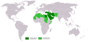
The Middle East is a region of Asia that is bordered by Asia to the east, Europe to the northwest, Africa to the southwest, and the Mediterranean Sea to the west. Parts of Africa (primarily Egypt and Sudan) are sometimes considered part of the Middle East as well. Many of today's countries of the Middle East were formed from the partitioning of the Ottoman Empire.
Economically, the Middle East is known for its vast oil reserves. It is also known as the home of three major world religions: Christianity, Islam, and Judaism. Because of its economic, religious, and geographical location, the Middle East has been at the center of many world issues and political affairs.
The Middle East is rich with history. Several great ancient civilizations were formed in the Middle East including Ancient Egypt, the Persian Empire, and the Babylonian Empire.
Population: 368,927,551 (Source: Estimate from population of countries included)
Bordering Bodies of Water: Mediterranean Sea, Red Sea, Gulf of Aden, Arabian Sea, Persian Gulf, Caspian Sea, Black Sea, Indian Ocean
Major Rivers and Lakes: Tigris River, Euphrates River, Nile River, Dead Sea, Lake Urmia, Lake Van, Suez Canal
Major Geographical Features: Arabian Desert, Kara Kum Desert, Zagros Mountains, Hindu Kush Mountains, Taurus Mountains, Anatolian Plateau
Countries of the Middle East
Learn more about the countries from the Middle East. Get all sorts of information on each Middle Eastern country including a map, a picture of the flag, population, and much more. Select the country below for more information:
Color in this map to learn the countries of the Middle East.
Click to get a larger printable version of map.
Fun Facts about the Middle East:
The most common languages spoken in the Middle East include Arabic, Persian, Turkish, Berber, and Kurdish.
The Dead Sea is the lowest point on earth at around 420 meters below sea level.
The land around the Tigris and Euphrates Rivers is called Mesopotamia. This is where the world's first civilization, the Sumer, developed.
The tallest building in the world (as of March 2014) is the Burj Khalifa building in the United Arab Emirates. It is 2,717 feet tall. That is more than twice as tall as the Empire State Building which is 1,250 feet tall.